About
The Athabasca Basin
The Athabasca Basin is a region in the Canadian Shield of northern Saskatchewan and Alberta, Canada, and is the world’s second-largest producer of uranium, accounting for roughly 13% of total global output. In 2023, the Province of Saskatchewan was ranked as the third most attractive jurisdiction in the world for mining investment—by the Fraser Institute.
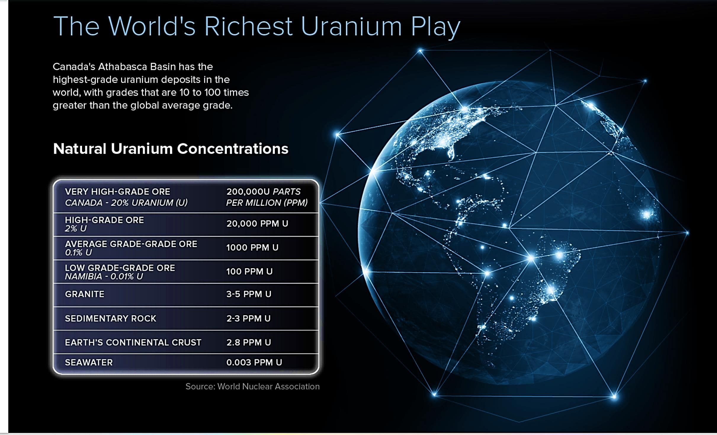
Figure 1. Athabasca Basin Uranium Statistics
The country’s Athabasca Basin has the highest-grade uranium deposits in the world, with grades that are 10 to 100 times greater than the global average1. The region— sometimes described as the “Persian Gulf of Uranium” is home to some of the world’s largest and highest-grade uranium mines including Cameco’s Cigar Lake; the world’s richest uranium mine, the McArthur River Mine, as well as the Key Lake and McClean Lake uranium mills. Over the past 40 years, uranium mining has produced over 900MM lbs of U3O8,with a known resource of 606,600 tonnes U3O8 2.
Geology
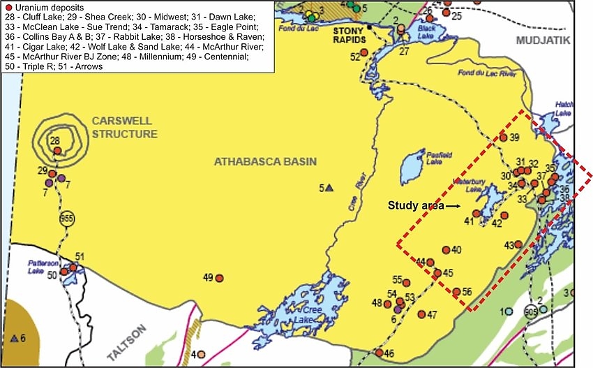
Unconformity-related uranium (“URU”) deposits are the most common in the Athabasca Basin, and include the highest grade, large tonnage deposits. URU deposits typically consist of uranium concentrations at the base of a Proterozoic sandstone sequence where it unconformably overlies pre–Middle Proterozoic metamorphic basement rocks. The deposits are often related to graphite-bearing structural zones, often termed ‘corridors’ or ‘trends’. Deposits are associated with faults or fracture zones and are usually accompanied with other metals such nickel, cobalt and arsenic. Significant numbers of Athabasca uranium discoveries to date has also led to the development of numerous exploration models which are commonly used to facilitate interpretations and prioritize target areas.

Figure 2. A map showing the distribution of the unconformity-related uranium deposits associated with the Athabasca Basin
The basin is a large, Paleoproterozoic-aged sedimentary basin covering much of northern Saskatchewan and a part of northern Alberta. At surface, the basin is an oval shape and covers and approximate dimension of 450 km by 200 km. It contains a relatively undisturbed sequence of unmetamorphosed clastic rocks, primarily sandstone, which are collectively referred to as the Athasbasca Group. The clastic rocks rest unconformably on the heavily deformed and metamorphosed rocks of the Hearne Craton, which is a part of the Western Churchill Province in the Canadian Shield. The basement rocks of the Hearne Craton include Archean orthogneiss, overlain by sedimentary rocks of the Paleoproterozoic Wollaston Supergroup. These basement rocks underwent metamorphism to the amphibolite facies and were structurally deformed during the Trans-Hudson orogeny, producing a pronounced northeast-trending linear fabric. Additional structural trends include east-northeast structures such as the Collins Bay Thrust and Tent-Seal Structure, north-south structures such as the Tabbernor Fault System, and northwest structures such as the diabase dykes that are pervasive throughout the basin.
The crystalline basement beneath the basin is composed of three primary lithotectonic zones: the Taltson Magmatic Zone (TMZ), the Rae Province, and the Hearne Province, collectively forming the basement assemblage. The TMZ underlies the westernmost portion of the basin, the Rae Province occupies the central region, and the Hearne Province lies to the east. The Rae Province is primarily composed of metasedimentary supracrustal sequences, along with granitoid rocks, whereas the Hearne Province predominantly consists of granitic gneiss. The TMZ is distinguished by a diverse range of plutonic rocks within an older basement complex exhibiting significant compositional variability, from amphibolites to granitic and pelitic gneisses.
The Rae and Hearne Provinces are separated by the large-scale, northeast-southwest trending Snowbird Tectonic Zone. In the southern part of the basin, this tectonic feature is locally referred to as the Virgin River shear zone, while in the northern part, it is known as the Black Lake fault. Other major fault systems include the Grease River shear zone, the Black Bay fault, the Cable Bay shear zone, and north-south trending Tabbernor-type fault zones.

