Properties
Eastern Athabasca Uranium Properties
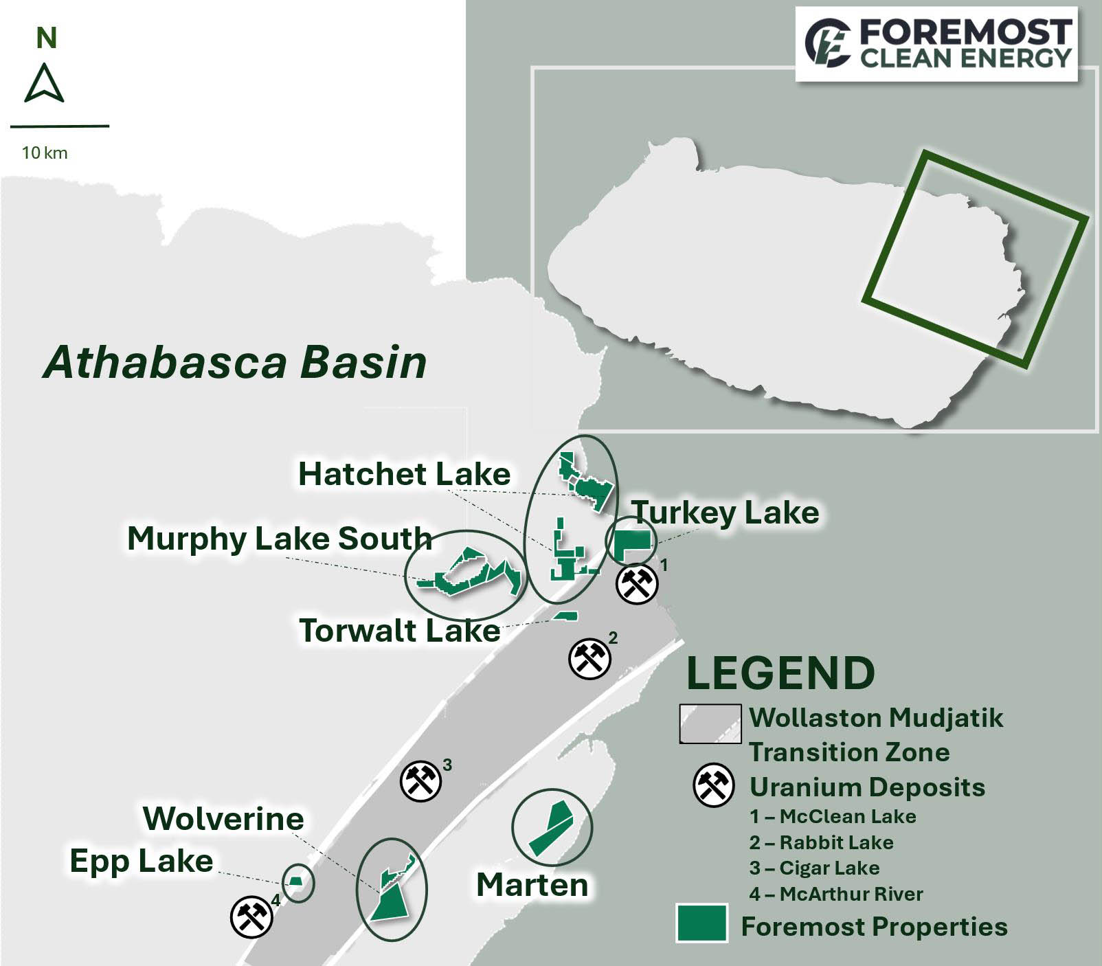
Seven properties comprise the Easern Athabasca Uranium Properties - Murphy Lake South, Hatchet Lake, Turkey Lake, Torwalt, Marten, Wolverine and Epp Lake. They are located in the eastern portion of the Athabasca Basin, which is host to considerable existing infrastructure including uranium mines and mills, and provincial powerlines and highways and is within or adjacent to the Wollaston- Mudjatik Transition Zone (WMTZ), which currently hosts all producing uranium mines and mills in the Athabasca Basin.
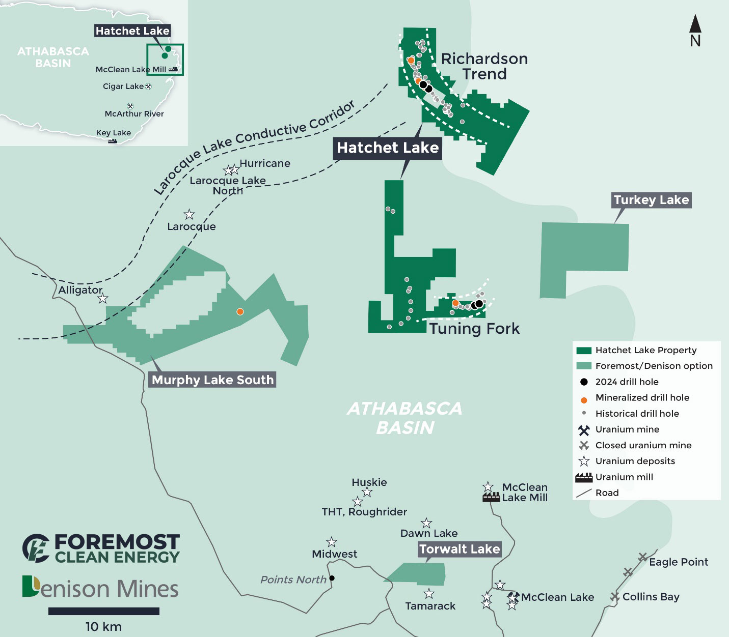
Figure 1. Map of Foremost’s Eastern Athabasca Uranium Properties, Saskatchewan
Uranium zones in the area typically are found to be near surface, basement hosted high-grade uranium mineralization. Some projects on-strike with geological trend that host rich uranium deposits with a mixture of shallow and deeper mineralization. The basement in this area is unconformably overlain by the Athabasca Group, specifically the Manitou Falls Formation, which covers most of the eastern portion of the basin. This formation can be sub-divided into four mains groups: 1. Dunlop (fine-grained sandstone, prevalent clay intraclasts); 2. Collins (sandstone member with a distinct lack of clay intraclasts); 3. Bird (sequence of interbedded sandstones and clast-supported conglomerates); and 4. Read (poorly sorted sandstone and conglomerate).
The Murphy Lake South Property
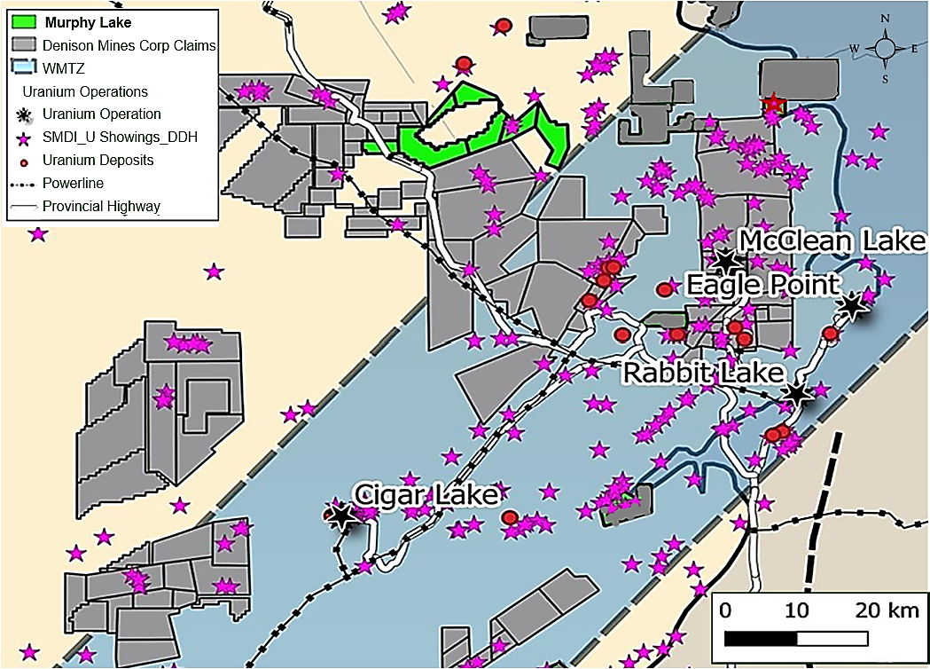
The Murphy Lake Property (“Murphy Lake”) comprises 6 mineral claims, totaling 17,676 acres / 7,153 hectares and is located approximately 30 kilometers northwest of the McClean Lake mill, within the eastern edge of the Athabasca Basin, Saskatchewan.
Figure 2. Murphy Lake Location Map
The Property is underlain by a 200- to 350-meter-thick cover of Athabasca Sandstone, which, in turn, overlies the metamorphic rocks of the Wollaston and Mudjatik Domains. The metamorphic rocks on the Murphy Lake property display structural trends more typical of the Mudjatik, with Archean granite-gneiss domes surrounded by keels of Wollaston Group metasediments, which consists of variably pyritic and graphitic pelites to semi-pelites and pegmatites on the property.
Historic Exploration and Drilling
A total of 12.8 kilometers of DC/IP data was collected along eight survey lines spaced at 200 metres in August 2014. The survey identified several zones of low resistivity in the sandstone column overlying previously defined fixed-loop EM conductors. These zones are interpreted to be associated with significant hydrothermal sandstone alteration related to reactivated basement faults, representing prime exploration targets.
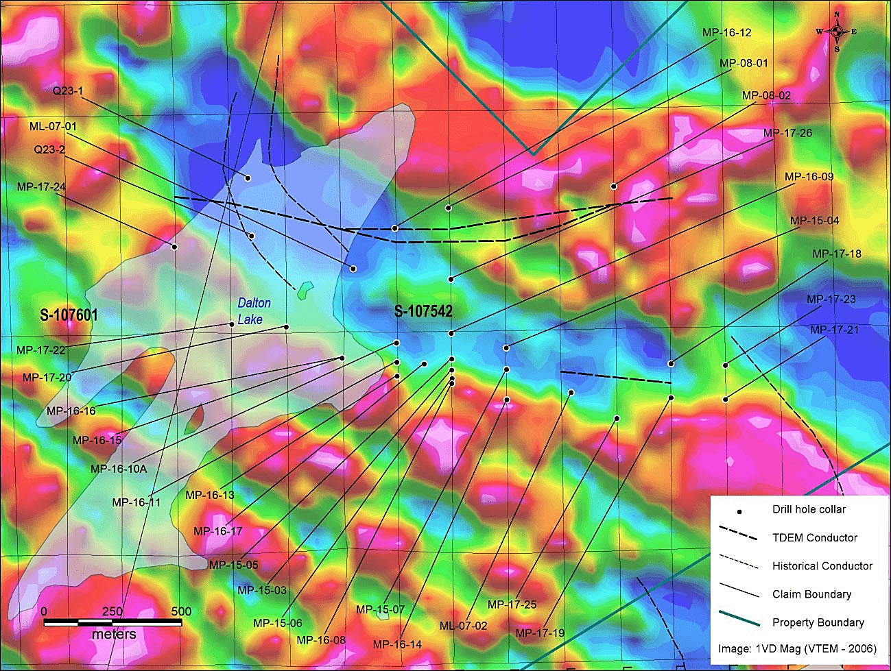
In July 2015, Denison carried out a diamond drilling program consisting of five holes, totaling 1,818 metres in the Murphy Lake grid area. The program focused on testing selected resistivity targets along the southern conductive tend, where limited historical drilling had intersected significant structure and alteration both in the sandstone and the basement.
The first hole of the program, MP-15-03, successfully encountered weak uranium mineralization over a significant width at the sub-Athabasca unconformity. Assays from the mineralized zone returned 0.25% U3O8 over 6.0 metres starting at a depth of 270.0 metres. The mineralization is associated with a zone of strong sandstone alteration which included DE silicification and clay alteration over a hematite cap. The target was an east-west oriented resistivity low anomaly that has been tested by only one other drill hole previously. Four additional drill holes were completed to follow up on the mineralization in MP-15-03. While none of the holes intersected mineralization, all encountered significant structure and alteration, suggesting the presence of a highly prospective system which is open to the west and likely to the east.
A ground geophysical program consisting of grid preparation and a Slingram Moving Loop TEM (“SMLTEM”) survey was completed on claims S-107587 and S-107584 during the winter 2015. The survey was designed to further define a prominent EM feature that runs northwest across the western portion of the property. The survey successfully identified a discrete conductor with moderate amplitude mid to late time response coincident with the airborne EM anomaly.
During the winter 2016 season, Denison completed a diamond drilling program, as well as ground gravity and DC-IP resistivity surveys on the Murphy Lake 2008 grid. Approximately 3,700 metres were drilled in 10 drill holes during the program. Most of the drilling was designed to test targets identified along strike and on section of MP-15-03 (a 2015 drill hole which intersected 0.25% U3O8 over 6.0 metres in strongly altered sandstones, immediately above the unconformity). Drilling confirmed the continuity of the intense hydrothermal sandstone alteration system, identified in 2015, over a strike length of 850 metres. Weak uranium mineralization was intersected in the sandstone associated with intense hematite and clay alteration in three drill holes (MP-16-08, MP-16-11 and MP-16-17). Drill hole MP-16-08, drilled on section with MP-15-03, identified uranium mineralization associated with a parallel graphitic fault zone, approximately 70 metres to the south. Drill holes MP-16-11 and MP-16-17 were both drilled along strike to the west of drill hole MP-15-03 at 200 metres and 100 metres, respectively.
Table 1: Summary of highlight intersections from the Murphy Lake 2016 Drill Program
| Hole ID | Depth From (m) | Depth To (m) | U3O8 % |
| MP-16-08 | 275.5 | 276 | 0.183 |
| MP-16-08 | 276.5 | 277 | 0.153 |
| MP-16-11 | 268 | 268.5 | 0.148 |
| MP-16-11 | 269 | 269.5 | 0.217 |
| MP-16-11 | 269.5 | 270 | 0.148 |
| MP-16-11 | 270 | 270.5 | 0.134 |
| MP-16-11 | 270.5 | 271 | 0.172 |
| MP-16-11 | 271 | 271.5 | 0.589 |
| MP-16-11 | 271.5 | 272 | 0.339 |
| MP-16-11 | 272 | 272.5 | 0.174 |
| MP-16-11 | 272.5 | 273 | 0.166 |
| MP-16-11 | 274.5 | 275 | 0.186 |
| MP-16-11 | 277.5 | 278 | 0.494 |
| MP-16-11 | 281.5 | 282 | 0.177 |
| MP-16-17 | 262.5 | 263 | 0.122 |
| MP-16-17 | 268 | 268.5 | 0.128 |
Figure 3: Murphy Lake Drill Hole Location Map
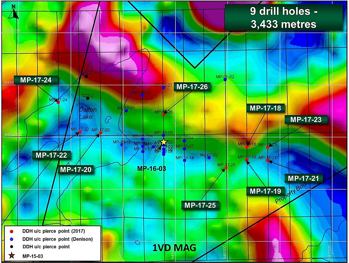
The 2017 field exploration activities on the Murphy Lake property consisted of diamond drilling in the Murphy Lake 2008 grid area. A total of nine drill holes for 3,433 metres was completed, primarily testing for potential strike extension of uranium mineralization identified in the 2015 drilling program. The 2017 holes evaluated untested resistivity targets along the mineralized Murphy Lake Trend, immediately to the west of the drilling coverage.
Drill hole MP-17-19 intersected altered sandstone with pervasive bleaching throughout and massive clay zones in the basal 50 metres of sandstone. Elevated radioactivity was observed from 333.0 to 339.0 metres, returning uranium values ranging from 126 to 1,320 ppm U, associated with strongly altered pegmatite and pelite. Follow-up drilling intersected localized structures but failed to identify alteration as intense as in MP-17-19. Other highlights from the 2017 program include MP-17-18, which intersected significant alteration in the basal 57 metres of sandstone, and MP-17-25 which intersected significant core loss from 264 metres to the unconformity and a locally faulted granitic unit.
Recent drilling in the Murphy Lake 2008 grid area has identified significant unconformity displacements of up to 96 metres vertically, between the northern and southern conductors. In 2016, several drill holes were completed to locate potential offset fault zone or zones, the plausible cause of the significant unconformity displacement seen in the area. Although no significant fault zones were encountered in these holes, the holes appeared to have intersected the hanging wall and footwall of a major fault zone, inferred from drilling.
Table 2: Summary of highlight intersections from the Murphy
|
Hole ID |
Depth From (m) | Depth To (m) | U3O8 % |
| MP-17-19 | 332 | 333 | 0.013 |
| MP-17-19 | 333 | 333.5 | 0.020 |
| MP-17-19 | 333.5 | 334 | 0.030 |
| MP-17-19 | 334 | 334.5 | 0.015 |
| MP-17-19 | 334.5 | 335 | 0.045 |
| MP-17-19 | 335 | 335.5 | 0.031 |
| MP-17-19 | 335.5 | 336 | 0.006 |
| MP-17-19 | 336 | 336.5 | 0.026 |
| MP-17-19 | 336.5 | 337 | 0.016 |
| MP-17-19 | 337 | 337.5 | 0.009 |
| MP-17-19 | 337.5 | 338 | 0.007 |
| MP-17-19 | 338 | 338.5 | 0.132 |
| MP-17-19 | 338.5 | 339 | 0.019 |
| MP-17-19 | 339 | 339.5 | 0.017 |
Figure 4: Murphy Lake 2017 Diamond Drill Program
Conclusion
Historic drilling on the property on the property discovered up to 0.06% U3O8 (DDH CRK-144) with unconformity depth ~350 metres. Murphy Lake shows great potential as conductors that host uranium mineralization extend on it. It is considered a priority with a number of drill targets already determined.
Hatchet Lake Property
The Hatchet Lake Property (“Hatchet Lake”) encompasses 9 mineral claims within 2 claim blocks (Richardson and South), totaling 25,234 acres/10,212 hectares located in the northeast region of the Athabasca Basin, approximately 400 kilometers north of La Ronge and 30 kilometers north of Points North Landing. Access to the property is via fixed-wing aircraft or helicopter from Points North Landing or by a network of winter roads running north from the McClean Lake mine sit located 23 kilometers south of the property’s southern boundary. Hatchet Lake is divided into four grids: Richardson, Beta, Hatchet South and Tuning Fork.
Figure 5. Map of Hatchet Lake Property
The property is within the eastern margin of the Athabasca Basin. Unconformity depths from zero to 250 metres, with depth typically increasing to the southwest into the basin. The basement rocks underlying the property include variably graphitic pelite, psammite, quartzite, granite, and minor amphibolite and calc-silicate. Hatchet Lake is along or adjacent to the LaRocque Lake Conductive Corridor, which hosts the Hurricane, Alligator, Crocodile and LaRocque deposits, as well as Cameco’s newly disclosed high-grade zone. The two key areas of interest are the Tuning Fork area in the south, an extension of the Moonlight on the McClean Lake Property, and the Richarson Lake trend, which trends northwest, effectively bisecting the northern claim block.
Historic Exploration and Drilling
Exploration work in the Hatchet Lake area began in the 1960s with the identification of various regional airborne conductors and the discovery of radioactive boulders (up to 7,500 CPS) and outcrop in the Garnet Hill area. Airborne and prospecting anomalies were followed up with ground geophysics, further prospecting, trenching, boulder and lake sediment sampling and diamond drilling. Some of the exploration and drill programs from 2007 to 2013 highlight are outlined below:
- 2007 - Three drill holes for a total of 856 meters were completed: drill testing was conducted to analyze a VTEM anomaly at depth, while the third hole was designed to test a TDEM anomaly from a historic Cameco survey.
- 2008- Three drill holes for a total of 6 metres were completed: best historical results in the 2008 Richardson Lake grid area were from a 1979 drill hole which had up to 800 cps in the basement associated with strongly altered sandstones above it.
- 2010- Ten holes for a total of 2,161.1 metres were completed in the Tuning Fork area: results were encouraging . The intersection of very strongly altered graphitic faults in drill holes HL-10-01, 02, 02B, 03 and 07 has generated a set of prospective targets. Highlights include Drill hole HL-10-03, which encountered over 100 metres of strong alteration and faulting in the basement units. Drill hole HL-10-01 encountered mineralized intervals grading 0.1% U3O8 and 0.02% U3O8, each over one meter within a broader zone of elevated radioactivity associated with faulted and strongly altered graphitic pelite approximately 50 metres below the unconformity.
- 2011- Three holes for a total of 801.7 metres were completed. Results from the three holes completed were encouraging as all three holes encountered fault zones, strong alteration, and low-grade mineralization hosted in basement rocks. Drill hole RL-11-01 intersected 0.4 metres of 0.13 % e U3O8 at the contact of a sulphide-rich pegmatite and 0.2 metres of 0.06 % e U3O8 in sulphide-rich pelite. Drill hole RL-11-02A intersected 0.8 metres of 0.15 % e U3O8 in fractured basement, while drill hole RL-11-03 intersected 0.3 metres of 0.06% e U3O8 at a pelite-granite contact.
- 2013 – Twelve holes for a total of 2,360.6 metres were completed: Significant uranium, gold and base metal intersections were encountered in several holes. Drill hole RL13-13 intersected 1.52 % U3O8 over 0.15 metres from 136.85 metres, approximately 5 metres below the unconformity, intersected at 131.6 metres. Drill hole RL-13-16 intersected uranium mineralization straddling the unconformity, grading 0.45% U3O8 over 2.3 metres, beginning at 124 metres down the drill hole and straddling the unconformity. As with drill hole RL-13-13, the mineralization is associated with hydrothermal hematite alteration. In addition to anomalous uranium, two consecutive 0.5-metre split basement samples from 134 to 135 metres in RL-13-16 returned gold assay values of 39.1 and 4 g/t.
2014 Exploration and Drilling
On April 30, 2014, a 2,038 metre, 10-hole program of diamond drilling was completed. The diamond drilling program had two main objectives: (1) to further evaluate the prospective structure and alteration encountered during the 2010 drilling campaign and (2) to test other areas of structural interest along the Tuning Fork Trend. Nine holes were drilled on claim S-107749, totaling 2,552.5 metres. A broad zone of weak uranium mineralization was observed near the unconformity in drill hole RL-14-19, which intersected 0.025% U3O8 over 8.5 metres from 124.2 to 132.7 metres. Additionally, significant base metal mineralization comprised of 3.3% Pb, 0.27% Zn and 19.6 g/t Ag over 9.6 metres was intersected in drillhole RL-14-27 from 148.0 to 157.6 metres.
2015 Exploration and Drilling
On June 04, 2015 it was reported that a total of 2,547 metres of drilling was completed in nine drill holes. The exploration program on the Hatchet Lake Project consisted of a diamond drilling program in the Tuning Fork grid area, a geophysical survey on the southernmost two claim blocks of the property, and a soil sampling survey in the Richardson Lake area.
A zone of intense basement clay alteration with elevated uranium values was extended by drill hole TF-15-01. The alteration is coincident with a strong fault zone within graphitic pelitic gneiss. The highest uranium value obtained in TF-15-01 was 491 ppm U, and was accompanied by impressive trace element results that include elevated copper (up to 2.4%), nickel (up to 0.1%) and cobalt (up to 0.29%).
Most of the 2015 drill holes intersected significant structure, alteration and elevated radioactivity in both basement and sandstone which may be indicative of a uranium mineralizing system that has been active in the area. TF-15-01 intersected anomalous concentrations of U, As, Cu, Bi, Co, Cu, Ni and B in a highly altered graphitic fault zone.
Table 3: Anomalous basement geochemistry in drill hole TF-15-01
| Hole ID | From (m) | To (m) | U-P (ppm) | As-P (ppm) | Bi-P (ppm) | Co-P (ppm) | Cu-P (ppm) | Ni-P (ppm) | B (ppm) |
| TF-15-01 | 213 | 213.5 | 18 | 434 | 76 | 432 | 24200 | 216 | 1950 |
| TF-15-01 | 216 | 216.5 | 36 | 2820 | 91 | 1000 | 5960 | 1350 | 194 |
| TF-15-01 | 234.3 | 234.8 | 56 | 921 | 18 | 751 | 926 | 181 | 190 |
| TF-15-01 | 234.8 | 235.3 | 302 | 4120 | 84 | 2920 | 17100 | 1030 | 265 |
| TF-15-01 | 235.3 | 235.8 | 21 | 384 | 5 | 336 | 137 | 125 | 156 |
| TF-15-01 | 235.8 | 236.3 | 43 | 1710 | 18 | 1130 | 676 | 435 | 196 |
| TF-15-01 | 245 | 245.5 | 167 | 524 | 40 | 386 | 5060 | 240 | 6160 |
| TF-15-01 | 245.5 | 246 | 491 | 1320 | 73 | 936 | 12000 | 428 | 3050 |
| TF-15-01 | 246 | 246.5 | 25 | 77 | 15 | 72 | 5220 | 39 | 362 |
| TF-15-01 | 246.5 | 247 | 38 | 110 | 43 | 132 | 14900 | 46 | 315 |
| TF-15-01 | 247 | 247.5 | 69 | 631 | 71 | 500 | 16800 | 218 | 313 |
| TF-15-01 | 247.5 | 248 | 74 | 888 | 57 | 671 | 6110 | 306 | 275 |
| TF-15-01 | 248 | 248.5 | 24 | 506 | 47 | 397 | 3550 | 215 | 260 |
Four lines of Slingram Moving Loop TEM were surveyed on two separate grids (HL-15-G1 and HL-15-G2 grids) located on claim S-107748 in early winter 2015. The survey successfully outlined several moderate conductive anomalies on both grids that extend beyond the limits of the survey area.
2016 Exploration and Drilling
The 2016 exploration program on the Hatchet Lake Property consisted of a Slingram Moving Loop Surface Transient Electromagnetic (SMLTEM) survey, followed by a diamond drilling program in the Hatchet South and Tuning Fork areas, and a reconnaissance surficial geochemistry survey over the interpreted south-eastern extension of the Richardson Lake Trend.16.8-line kilometers of SMLTEM data were collected along seven lines in the Hatchet South area. The results of the survey were I nterpreted to represent a generally moderately to steeply easterly-dipping, moderately conductive feature that can be traced across the entire length of the survey area.
A diamond drilling program totaling 2,040.0 metres in six holes was completed in the Tuning Fork area to follow up indicative results from historical drilling and to test EM anomalies from the identified from the 2015 and 2016 surveys.
Conclusion
Hatchet has a virtually untested basement potential with known mineralization along Richardson trend with over a strike length of ~5 km, and uranium and base metal enrichment at Tuning Fork and displays shallow depth to unconformity. The intensity of the alteration and geochemical results, combined with the presence of structurally prepared graphitic basement suggests that the area is highly prospective for high grade basement hosted mineralization and further drilling is required.
Turkey Lake Property
The Turkey Lake Property (“Turkey Lake”) consists of one mineral claim over 9,363 acres/3,789 hectares on the eastern margin of the Athabasca Basin Saskatchewan. The property is well situated, bordering the northern claim boundary of Denison’s Wolly JV project, operated by Orano Canada, approximately 23 kilometers north of the McClean Lake Mill, and approximately 25 kilometers north of the Eagle Point Mine. Access to the property is by aircraft from Points North Landing, by the Hatchet Lake Lodge winter road (permission required), or through a network of winter roads north from the McClean Lake Operation site.
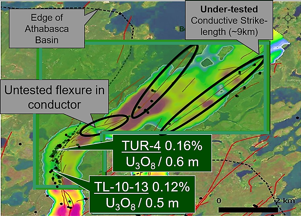
Figure 6. Map of Turkey Lake; Background: VTEM TauBF
Historic Exploration and Drilling
The Turkey Lake Property was explored by Gulf Minerals and Cameco Corporation between 1979 and 2009, often as part of larger property work in the immediate vicinity. The best results to date occur along the sandstone-covered portion of the Turkey Lake conductors, in a series of holes drilled by Gulf in the late 1970s, the best of which was TUR-4 which intersected 0.136% U3O8 over 0.6m. The intersection was within the sandstone column just above the sub-Athabasca unconformity at a vertical depth of only 20 metres. Follow-up holes drilled within the vicinity of TUR-4 also intersected significantly elevated radioactivity.
A ground soil sampling program was performed for Denison Mines Corp. by Durama Enterprises Ltd. from September 15, 2015, to September 23, 2015. The survey consisted of 720 sample stations collected over 2 grids: one just north of the TUR-10-G1 grid and a second survey in the east-northeast portion of the property. Preliminary results of analysis of the soil sampling data suggested a zone of anomalous uranium in the soils, associated with an interpreted magnetic low, as well as a gravity low to the north.
Conclusion
Turkey Lake is underexplored with known mineralization. It displays shallow depth to unconformity (<50 m) with multiple holes on the property identifying unconformity-associated mineralization. Previous drill holes have confirmed uranium including results at drill holes TUR-4 0.16% U3O8 / 0.6 m and TL-10-13: 0.12% U3O8 / 0.5 m. The property has virtually untested basement potential including possible analogue for Collins Bay/Eagle Point. Results from Purepoint’s Osprey zone, along trend to the south, vector onto Turkey Lake property.
Torwalt Property
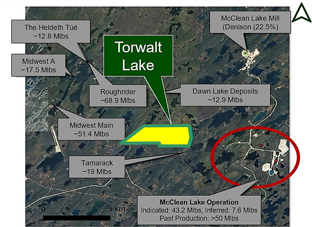
The Torwalt Property (“Torwalt”) is on 1 claim over 2,007 acres/812 hectares, bordering the McClean Lake in the infrastructure-rich eastern portion of the Athabasca Basin. The Torwalt Lake Property is located five kilometers east of Points North Landing. The Property is well situated between the Midwest (Orano-Denison), Tamarack (Cameco-Orano), and McClean Lake (Orano-Denison) Uranium deposits. Provincial Highway 905 passes through the southwestern tip of the property, and drill roads extend through the western half of the claim.
Figure 7. Map of Torwalt Lake Uranium Property
The property is underlain by sandstone of the Athabasca Group, which unconformably overlie highly deformed and metamorphosed rocks of the western Wollaston Domain of the Hearne Province.
Torwalt’s location between several deposits emphasizes the area’s prospectivity. While the results of tow airborne EM surveys indicated that no electromagnetic conductors are present within the property, faulted graphitic lithologies were intersected by 2016 drill hole TWL-16-02. These graphitic lithologies were underlain by granite, interpreted to represent the Torwalt Dome. This faulted graphitic pelite overlaying a granitic dome is somewhat analogous to what hosted mineralization at Cameco’s Rabbit Lake operation, where mineralization is hosted within the Collins Bay fault, where it overlies the granitic Collins Bay Dome. This scenario provides a competency contrast that may have acted as a conduit and trap for mineralizing fluids.
Torwalt is underexplored with only 2 existing drill holes on property. The geology on the property consists of graphitic sediments overlying granitic dome and has potential to identify Key Lake or Collins Bay analogues with further exploration and drilling.
Marten Property
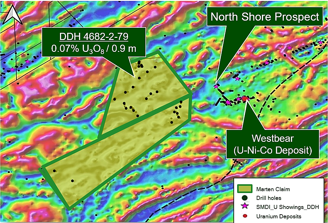
The Marten Property (“Marten”) is comprised of 2 claims over 12,375 acres/5,008 hectares located on the eastern edge of the Athabasca Basin along the Umpherville trend which hosts the North Shore Project (up to 2.14% U3O8 / 2.44m). It is approximately 30 kilometers southeast of the Cigar Lake Mine (Cameco).
Figure 8. Map of Marten Property; Background: Airborne Magnetics (TDR RTP)
The property is underlain by less than 100 metres of Manitou Falls Formation sandstones on its eastern side to more than 130 metres on its western side. The basement rocks belong to the Wollaston Domain.
Historic Exploration and Drilling
In March 2010, a six-hole, 987 metre diamond drill program was completed. The holes were drilled in a north-south fence across the eastern end of the property to evaluate the property geology and determine if offsets in the unconformity elevation were present. Offsets of up to 11 metres were observed along the fence, indicating that post-Athabasca reactivation of structures has occurred. This is a key component of the unconformity uranium model. During the winter of 2016, a four-hole diamond 1,006 metre drill program to test resistivity anomalies at or below the inferred unconformity contact.
Highlights of previous drilling on the the property identified up to 96 m of unconformity offset associated with reverse fault at north end of property including low-grade mineralization (0.07% U3O8/ 0.9 m in DDH 4682-2-7, and the area remains prospective for basement-hosted uranium deposits.
Wolverine Property
The Wolverine Property (“Wolverine”) is comprised of 3 claims totaling 12,444 acres/5,036 hectares located on the southeastern edge of the Athabasca Basin, approximately 15 kilometers southeast of the Cigar Lake Mine Site (Cameco) and 30 kilometers south of Points North Landing. Winter access to the property can be gained via the Cigar Lake Road and the winter rock into the Park Creek Project.
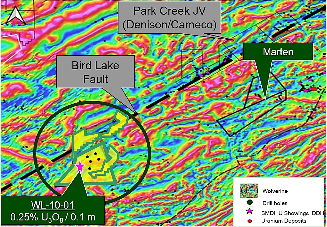
Figure 9. Map of Wolverine Uranium Property; Background: Background: Airborne Magnetics (1VD)
The property is underlain by the Athabasca Group sandstones, which in turn overlie metamorphic rocks of the Wollaston Domain. The depth to the unconformity is between 140 metres and 250 metres. Wolverine hosts existing mineralization at a shallow depth.
Historic Exploration and Drilling
The Company has historic drilling records dating back as early as 1969. Some highlights include the drill program conducted in June 2010 which intersected 2,087 ppm U-p over 0.1 metres within a two-meter interval, averaging 446 ppm U-p in drill hole WL10-01.
Additional past drilling has dentified uranium mineralization with peak mineralization grading 0.25% U3O8 over 0.1m, hosted in cataclastized pegmatite and a unconformity depth ~250m. The property shows a potential for an extension of Bird Lake Fault, which hosts multiple mineralized showings to the NE on the Park Creek JV. Historical drilling identified uranium mineralization with peak mineralization grading 0.25% U3O8 over 0.1m, hosted in cataclastized pegmatite.
Epp Lake Property
The Epp Lake Property (“Epp Lake”) is comprised of 2 claims 2,137 acres/865 hectares on the southeastern edge of the Athabasca Basin, located approximately 20 km northwest of the McArthur River Mine. Access to the property is by aircraft or by winter road from McArthur River haul road.
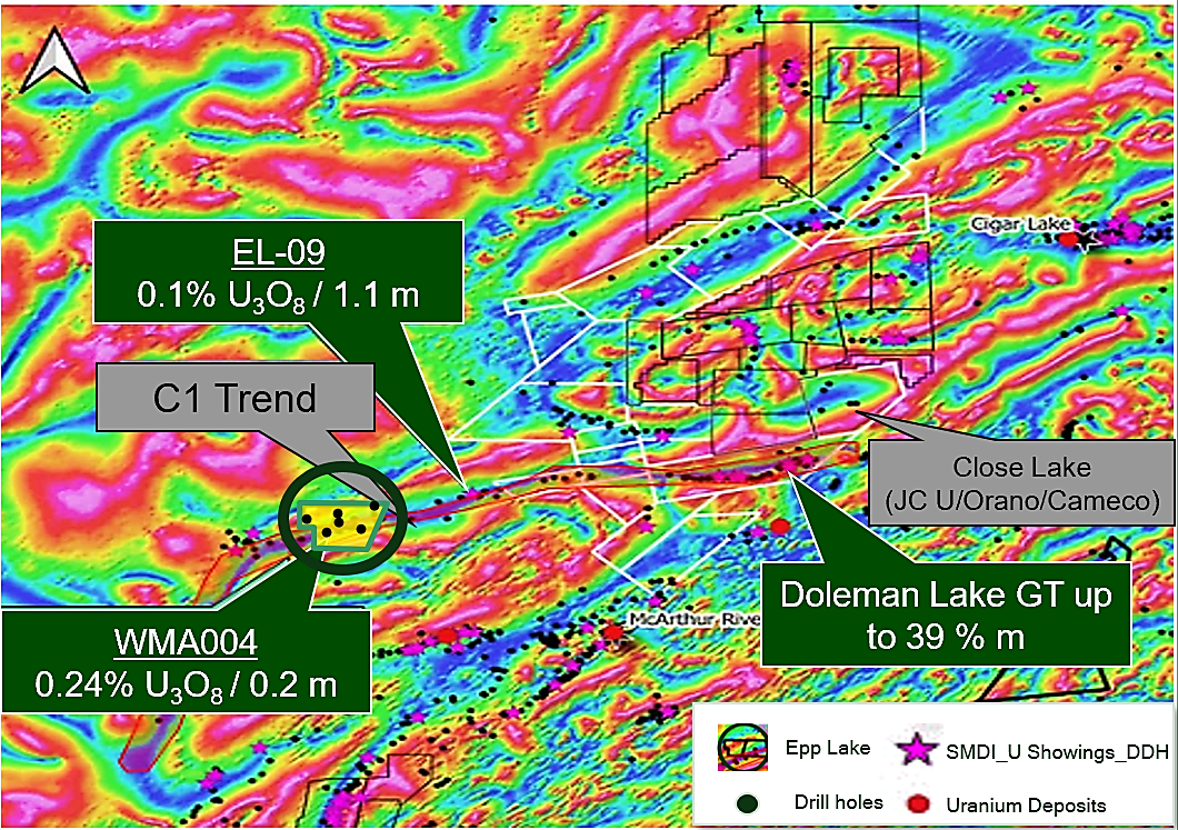
Figure 10. Map of Epp Lake Uranium Property; Background: Airborne Magnetics (TDR RTP)
Historic Exploration and Drilling
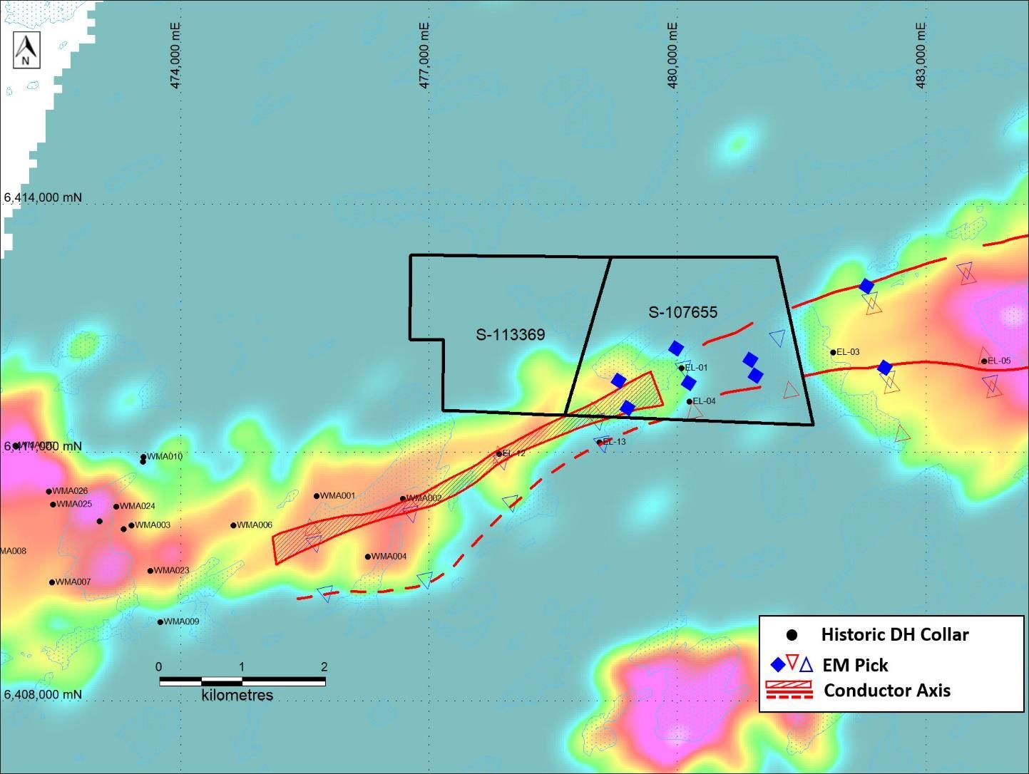
Exploration commenced in the Epp Lake area in 1985 by Uranerz Exploration and Mining, later continuing under a Uranerz-Cameco joint venture. Historical work includes lake sediment and boulder sampling, drilling, and electromagnetic (EM), magnetic and gravity surveys. EM surveys defined multiple conductors trending through the eastern portion of the property.
Figure 11: Epp Lake conductors and drill holes
Epp Lake is underexplored with known mineralization. Exploration on the property included 2008 ML TEM survey which showed distinct conductive response associated with C1 conductor trend. Extension of C1 conductor trend, which hosts multiple uranium showings along trend to the East, including up to 39 GT at Doleman Lake. Historic drilling includes 2 holes drilled at roughly 800 metres UC depth, showed significant structurally-associated alteration in lower sandstone coincident with anomalous geochemistry.

